
PAKISTAN
Fierce Face-off
By Jenny McGlone
Chapel Hill, NC, United States
What defines a nation? Is it simply a matter of geography? To what extent do common languages, cultures, religions, and politics make a difference when establishing borders?
These were questions faced by the leaders of British India in the middle of the 20th century. For many years, the Muslim and Hindu religious communities coexisted, but under British rule the two groups fractured. When violence erupted, Great Britain agreed to separate the subcontinent into two countries, one predominantly Muslim and one Hindu-majority.
Partition
This 1947 separation, known as Partition, created the independent nations of India and Pakistan. Pakistan was formed from Muslim-majority areas in the northwest and the east, while the remaining territory became newly independent India, governed by a Hindu-dominated legislature. The next difficult decision was where exactly to draw the borders between the two countries.
A British lawyer named Cyril Radcliffe was chosen to find the answer to this question. He spearheaded two commissions that, in five short weeks, drafted a map seeking to distribute areas according to religious representation. The new India–Pakistan borders were publicly announced on August 17, 1947.
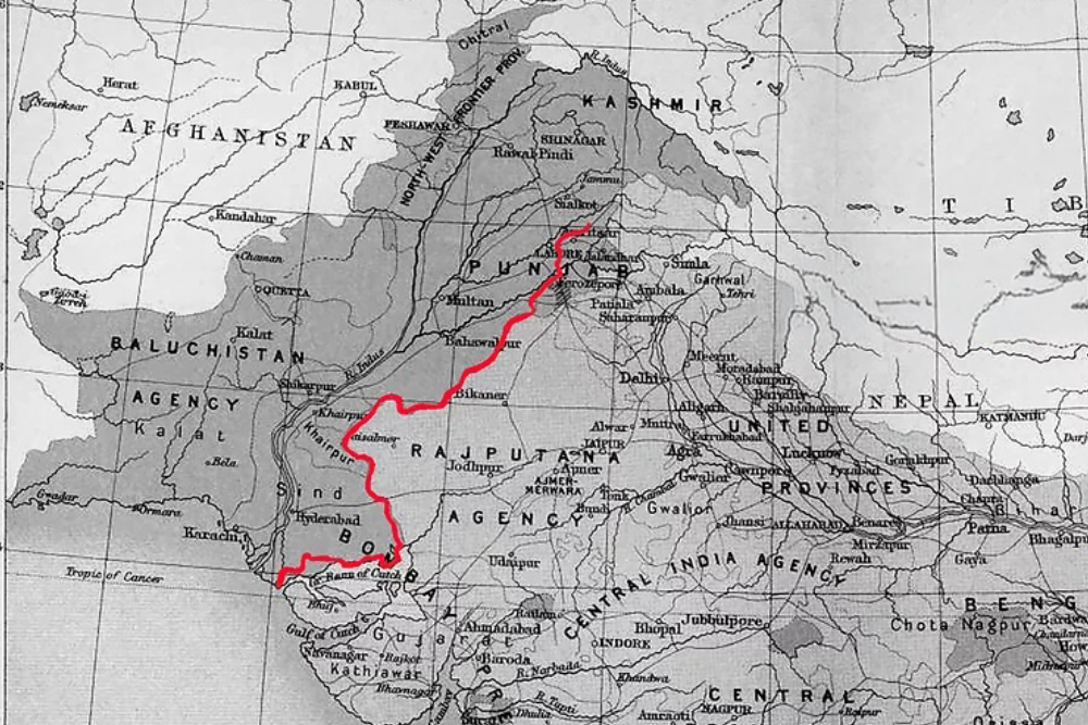
The western section of the 1947 India–Pakistan border, shown on a 1909 map of British India. Adaptation of map “Partition Anti-Memorial Project” by Pritika Chowdhry. Licensed under CC BY-SA 4.0.
Migration Crisis
When the Radcliffe Line was made official, roughly 14 million people crossed between the new countries in one of history’s largest mass migrations. Many Muslims traveled toward Pakistan, while many Hindus and Sikhs traveled toward India. Violence and uncertainty drove people from their homes. Estimates of the number killed vary widely, but hundreds of thousands—and possibly more than one million—lost their lives.
Since that crisis, tensions between Pakistan and India have risen and fallen over time. The countries have fought wars over the region of Kashmir. They also clashed in 1971, when East Pakistan became the independent nation of Bangladesh. One unique outcome of this long-standing friction can be witnessed every day at the Attari–Wagah border crossing between the two countries.
Putting the Flags to Bed
At a location 600 meters east of the village of Wagah, Indian and Pakistani security forces have participated in a flag-lowering ceremony since the late 1950s. Officially known as Beating the Retreat, it begins just before sunset with a precisely choreographed parade of soldiers from both countries. The pageantry draws thousands of spectators who marvel at the specially trained soldiers’ impressive high kicks and vigorous marches, sometimes set to drumbeats.
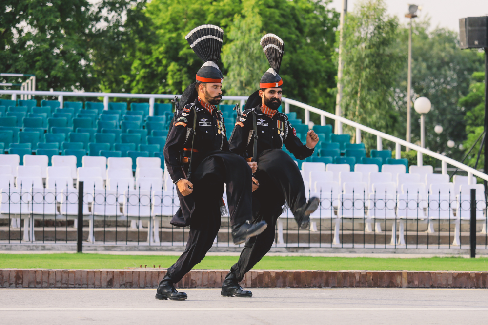
Plume-adorned hats, elaborate uniforms, swinging fists, and scowling faces create an intimidating display. Patriotic chants reverberate from loudspeakers, eliciting shrieks and applause from the audience.
The ritual reaches its climax as the Indian and Pakistani flags descend from their poles at exactly the same speed. Soldiers fold the flags and carry them away, but the gates between the countries remain firmly closed. Since 2025, the parade leaders have not exchanged the brisk handshake that once ended the ceremony.
Despite the stern showmanship, the ceremony’s atmosphere is festive. Visitors dance to Bollywood music before taking their seats in the stadium. Afterward, they take selfies with the soldiers from their own country. The spectacle is not only a marvel of entertainment but also a symbol that rivalry and cooperation can exist side by side.
Have a suggestion for this story? We’d love for you to submit it!
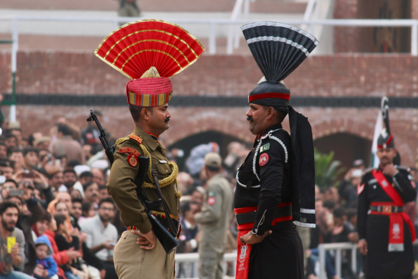
Adaptation of “Beating Retreat” by Gargisharma13. Licensed under CC BY-SA 4.0.
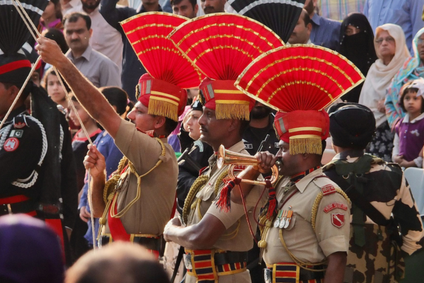
Adaptation of “Wagah” by Phil Parsons. Licensed under CC BY-NC-SA 2.0.
Blank
Blank
Slideshow
Are you a teacher who’s interested in telling this story to your students? Here’s a slideshow you can use to get started.
Math Resources
Learning Activity:
- Linear Equations (High School)
Sample Problems:
-
- Take a look at the Border Post on Google Maps, using the Satellite layer. Estimate how many people can watch the ceremony on each side of the gate. Which country can have the larger crowd?
- In 2017, India built a flagpole on its side that reached 360 feet in height. Five months later, Pakistan raised a 400-foot-high flagpole. How many feet taller is Pakistan’s flagpole? How many meters taller? Does the difference between the two heights change depending on whether you use feet or meters?
- How high is 400 feet? Is there anything in your community that is 400 feet tall? About how many stories is that height?
- Why do you suppose India doesn’t just put in a new, taller flagpole?
- A typical flagpole is about 70 feet tall. A person should be able to raise a flag to the top in about 30 seconds.
- At that rate, how long would it take to raise flags at Wagah?
- If the Pakistanis and Indians raised their flags at the same rate, which would arrive at the top first?
- What assumptions do you need to make for your answer to make sense?
- What would need to happen for your answer to be reversed? That is, if you said the India flag would reach the trop first,what would need to happen for the Pakistan flag to reach the top first (assuming both flags were raised at the same speed)?
Social Justice Questions
Since the 1947 partition, India and Pakistan have fought over the region of Kashmir, which lies between them.
- With both countries having nuclear weapons, any escalating conflict could have global consequences. What do you think should be the role of your country in the relationship between Pakistan and India?
- More than 15 million people live in Kashmir. In the Kashmir Valley, which is home to the largest share of the region’s population, about 97 percent of them are Muslim, according to recent census data. Do you think it’s more fair for Kashmir to belong to Pakistan, India, or to be its own independent country? Explain your reasoning.
Explore Further
- More information about the partition of India
- History of Pakistan and India’s relationship
- A story map of the ceremony
- Video of soliders lowering the flags
Share Your Story
Write your own Global Math Story and send it to us!
 English
  Spanish
Sorry, the comment form is closed at this time.